How a Towed Float Behaves
A positively buoyant float tethered to a moving diver does not stay directly overhead. Three forces act on it:
-
Buoyancy, pushing it up. Constant.
-
Drag from the water around it and from any wind on its exposed surfaces. Variable.
-
Tension on the tow line, pulling it toward the diver's position. Variable.
During steady forward swimming, drag pulls the float behind the diver — it trails. During a turn or a stop, the float overshoots the diver's new position and oscillates back. The implications for your survey: the float position is not a reliable indicator of the diver's instantaneous position, and any data acquired while the float is in motion (mid-turn, mid-oscillation) is geometrically suspect.
The Surveyor's Pivot, Step by Step
At the end of each lane, before turning to the next, execute this procedure:
-
Halt forward momentum. Gentle reverse frog-kick or no kick at all.
-
Maintain neutral buoyancy at constant depth. Do not let yourself drift up or down. No bottom contact.
-
Pause for five to ten seconds. Look up. The float should settle directly overhead.
-
Execute a stationary 180° turn in place.
-
Step laterally by the calculated lane spacing. (You'll have computed this in Module 1.)
-
Resume forward swimming.
Skipping the pause is the most common mistake students make. It is also the mistake that does the most damage to data quality. A moving turn drags the float through a wide horizontal arc on the surface, and your sonar pings that arc. The result is a curved track instead of a straight lane, and gaps in coverage between lanes.
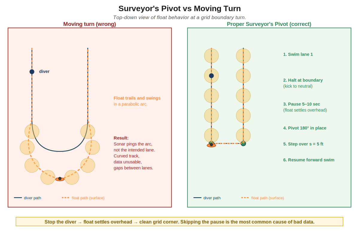
Figure 5. The Surveyor's Pivot vs a moving turn. Top-down view of a grid-boundary turn. Left: the float arcs wide and the sonar pings the arc, destroying the data. Right: pause for the float to settle, pivot in place, step over, resume.
A Simple Trick: Carry a Pre-Measured Line
Step 5 — stepping over by exactly your lane spacing — is usually done by eye, and eyeballing a distance while you are managing a spool, a heading, and your buoyancy is exactly when it drifts. An easy fix: cut a line to your planned lane spacing (say, 5 ft for 5 ft spacing) and carry it. At each turn, use it to measure the lateral step instead of guessing. Your lanes come out evenly spaced, your data is cleaner, and your map is easier for a future diver to re-create.
Two things to get right. First, this line measures how far to step over — it is not a tether tying you to your teammate. The single float still defines the track; the line just helps you place each pass a consistent distance from the last. Second, ordinary cord stretches when it is wet and pulled tight, so a “5 ft” cord might really be 5 ft 4 in. Use a low-stretch line (Dyneema) or a marked rigid rod, and write down the length you actually measured, not the number you meant it to be.
Careful: a second line is a second entanglement hazard
Anything you carry that can loop, trail, or snag is an entanglement risk — and you already have a tow line in the water. A measuring line is only worth carrying if you keep it under control. Keep it short and stiff (a marked rigid rod is much safer than floppy cord), keep it stowed except for the few seconds you are actually measuring, never let it trail behind you or form loops, never clip or tie it to yourself, and make sure your cutter can reach it. If you are not confident you can manage a second line cleanly, don't carry one — a rigid rod, or just careful eyeballing, is better than a loose rope around your gear. When in doubt, leave it out.
Spool vs Reel: Why the Rule Exists
A finger spool lets line pay in and out freely against light hand tension. You constantly adjust that tension to keep the line just-loaded — not loose enough to entangle, not tight enough to pull the float under. It is a dynamic, manual control.
A locking or ratcheting reel creates a rigid mechanical coupling between you and the float. Every depth change you make transmits directly to the float as a vertical force:
-
You drift down 1 m → the float drops 1 m → the GPS antenna submerges → you lose your track.
-
You drift up 1 m → the line pulls tight → you get jerked further upward → uncontrolled ascent risk.
Drag-heavy tube DSMBs amplify this effect because of their larger water resistance. Both ratcheting reels and drag-heavy DSMBs are prohibited as the tow float for this course.
Tow-Line Emergency Protocol
The tow line is hand-held only. Do not clip it to your BCD, tie it to equipment, wrap it around your hand, or route it through a fixed attachment point. You must be able to drop the spool instantly. Each team carries cutting capability and rehearses the sequence: stop, establish buoyancy, drop or cut if needed, signal teammate or instructor, regroup, and either recover the float from the surface or abort.
The Boat Strike Problem
A surface float being towed by an invisible diver is a high-consequence risk. Jet skis, rental boats, fishing skiffs, and inattentive recreational craft routinely run over divers' floats. The diver below is unaware until something goes very wrong.
The surface team has two jobs. The Surface Watch protects the diver and float system from traffic and surface hazards. The Surface Data Operator watches the Fish Deeper app, recording status, GPS lock, float submersion, and data continuity. In a quiet controlled site, one person may be able to do both. In traffic or complex conditions, those jobs should be separated.
Required mitigations for this course:
-
Display a dive flag on the float. Alpha and/or red-and-white diver-down per local jurisdiction. Mount it visibly.
-
Choose a site with no boat traffic, or with surface support that controls the area.
-
Maintain a dedicated surface watch — a support boat, support diver, or shore observer with line-of-sight — for the entire duration of every dive.
-
Verify that the float will keep the GPS antenna out of the water in the expected conditions. If the antenna goes under, you lose GPS — and the antenna goes under when wave action exceeds float reserve buoyancy.
Self-Check
1. Why does a moving turn distort the grid even if your compass heading is correct?
2. You feel a strong upward tug on your tow line. What is most likely happening, and what is the danger?
3. Your float has a 0.5 lb reserve buoyancy in calm water. Conditions worsen and waves are now 1 ft. What can go wrong?
4. Why is clipping the tow line to your BCD prohibited?
Answers
1. The float lags behind you during forward motion and overshoots during turns. A turn made while moving sweeps the float through a horizontal arc on the surface; the sonar pings that arc; the resulting track is a curve, not a clean corner. Your compass heading reflects where you are pointed, not where the float (and therefore the data) is.
2. Most likely your buoyancy has gone positive and you are starting to ascend. The line pulls tight and accelerates the upward motion. Danger: uncontrolled ascent, potentially through the float at the surface. Vent BCD, exhale, and re-establish neutral buoyancy immediately.
3. Wave action that exceeds the float's reserve buoyancy pushes the antenna under, sometimes momentarily and sometimes persistently. Each submersion is a loss of GPS lock and a gap in your track. Either accept the data loss, or surface and abort.
4. A clipped or fixed tow line can turn float drag, current, or your own depth change into an uncontrolled pull. It can submerge the float, jerk you upward, trap you in line, or delay release during an emergency. Hand-held line control keeps immediate release available.